
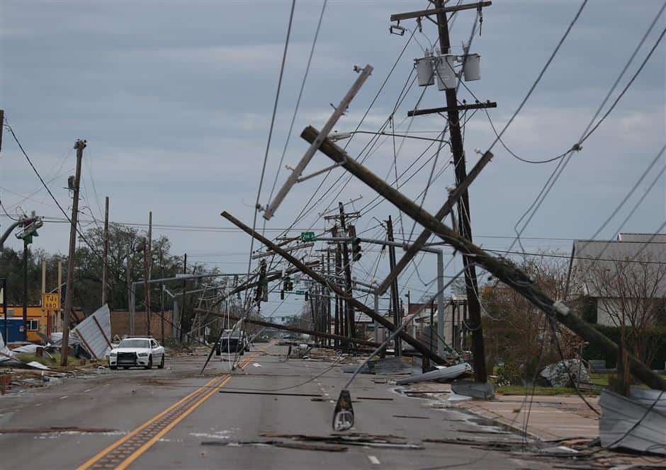
Hurricane Laura Hit Louisiana: An ‘Un-Survivable’ Hit Especially For Rural Areas
Nikki Attkisson | Last Updated : August 29, 2020Storm surge created by Hurricane Laura has feared South Louisiana’s officials and but the wall of water appeared was less than affected. When the category four storm came into shore on Thursday, even though it was potentially deadly, the effect was less than predicted.
Hurricane Laura Hit Louisiana: An ‘Un-Survivable’ Hit Especially For Rural Areas
The prediction was Hurricane Laura to bring a maximum of 20-foot storm surge, mainly in Cameron Parish. The floodwaters were predicted to be a maximum of 40 miles in the inland. Because of these estimates, earlier this week, the National Hurricane Center issued advised about an un-survivable storm surge. The storm surge was expected to come with highly destructive and large waves.
But, when the storm surge made landfall, the surge crested almost nine feet in Cameron Parish based on initial reports. Earlier, the storm surge level was considered life-threatening mainly because cars and other more significant items floated. More than that, the water level was expected to reach at least the top of the one-story building. But, finally, it didn’t get the level expected.
“Caught a break” yes, Gov. John Bel Edwards said on Thursday.
One of the specialists from The National Hurricane Center storm surge, Jamie Rhome, said to USA TODAY that “Based on the initial analysis, the surge was expected to bad mainly in Cameron Parish.” Rhome also added that” But the reported lower reading that is nine feet may have been seen on far western in the parish and not the east side. In the east, the surge was higher.”
“Since there is no proper observation, it is not right time to say that the surge was only ‘x’ feet,” he added. “On the East of Cameron, Louisiana, our hindcast model analysis has suggested that the forecast was ten to twenty feet, and that is verified.”
Ryan Truchelut, the chief meteorologist and co-founder at WeatherTiger, said that “But in Cameron Parish this time the Laura storm surge exceeded to date watermark.”
Further East from Laura’s center, in Iberia Parish, is the place where the storm surge was expected to reach 9 feet, officials were able to report three feet storm surge. Their assessments suggest three feet storm in Port of Iberia, Delcambre.
The director of public affairs, Katherin Breaux at Iberia Parish Sheriff’s Office, said: “We are fortunate because the storm surge was never reached the expected levels.”
Trucheult added, “But, in rural areas, the storm surge may have reached the expected 20 feet. This is mainly the uninhibited marshy area present along with Louisiana coaster, which is near landfall.”The National Weather Service is going to send teams for further evaluation of what the storm surge could have been reached. But till then, it is difficult to rule out the more massive surge.
He also added that “To the east of Cameron, where there is eastern eye-wall is present, there is no observation.” ”Of course there is a gauge in Vermilion Bay and Cameron, but between the two, there is less, and this is the place where strongest north and south winds arrive.”
The area is rural towns and marsh, and that is the main reason there is less number of reporting devices. There will be fewer structures to analyze for signs of storm surge when the Weather Service Teams reach there to evaluate.
Truchelut also said that there are many reasons behind the storm surge likely to be lower than the earlier predictions.
The primary reason was, the storm model used to predict the storm surge takes several factors into account. Some of these are the wind field and topography. There may be many other factors taken into account by storm models while analyzing and predicting the upcoming storm surge levels.
After this, the worst-case and most reasonable scenario will be presented. Through this, they try to give an idea for people what actually could happen when the storm surge arrives. The storm models also try to predict the range of that scenario and present the storm surge, Truchelut said.
Truchelut said another factor considered by storm model is the wind flow. Hurricane Laura’s center came up from Cameron, Louisiana, and it was straight over Lake Charles. Highly predominant wind flow of the storm started flowing from east to west. It created damaging winds, and meantime, it was not pushing the water up at the Calcasieu River.
He also added that “The track of the Lake Charles was horrible for the wind. But the track never drove the storm surge up, and it never pushed it towards Lake Charles.”
Once the Laura made landfall, the storm was predicted to weaken all of a sudden when it makes its way to the north, and then it turns northeast. Other than Laura, in 2017, Harvey was a major hurricane that made landfall in Texas. The Harvey showed up to 130-mph of maximum winds. But, in 2005, it was Rita, which made landfall in Louisiana, and it was with 115 mph maximum winds.
So, finally, Laura Hurricane didn’t bring the expected storm surge of 20-feet in Cameron Parish. Even though the flood water was predicted much more than the real, it was no 40 miles inland. In reality, the storm surge made landfall, and it was in Cameron Parish, but it was not more than nine feet of surge crested in this area based on the initial reports.
Hurricane Laura is the strongest storm of this year in the U.S. It has led thousands of residents to evacuate the affected area even before the landfall. Based on the storm model, the forecasts gave warning that the storm is capable of catastrophic damage. To date, there are four deaths reported from Louisiana due to Hurricane Laura.
As Laura moved towards inland, it weakened to a tropical storm. It moved along bringing winds, rainfall, and flooding over central as well as northern Louisiana based on the reports by National Hurricane Center. According to the forecasts, high water levels continued majorly along with the parts of the Gulf coast.

With over 15 years as a practicing journalist, Nikki Attkisson found herself at Powdersville Post now after working at several other publications. She is an award-winning journalist with an entrepreneurial spirit and worked as a journalist covering technology, innovation, environmental issues, politics, health etc. Nikki Attkisson has also worked on product development, content strategy, and editorial management for numerous media companies. She began her career at local news stations and worked as a reporter in national newspapers.